Creating Mapping Applications with the ArcGIS API for JavaScript and Dojo Bootstrap

When the design team doesn’t do Dijit*

Recently, our design team delivered a functional HTML wireframe that was developed with Twitter Bootstrap. Ordinarily that would not be a problem, but the application we’re working on is based on the ArcGIS API for JavaScript and as such relies entirely on Dojo. The developers wanted to be able to leverage as much of the designers work as we could without having to include jQuery – a dependency of Bootstrap’s JavaScript components. A little digging around lead me to Kevin Andre’s Dojo Bootstrap project – a pure Dojo implementation of Twitter Bootstrap. We were able to successfully use Dojo Bootstrap in our ArcGIS API for JavaScript based mapping application. This enabled us to leverage the declarative mark up and styles already written by the designers without adding a jQuery dependency.

Just in time for the 2013 Esri International Developer Summit, I’ve created a simple application that demonstrates how to incorporate Dojo Bootstrap with the ArcGIS API for JavaScript:

Continue reading “Creating Mapping Applications with the ArcGIS API for JavaScript and Dojo Bootstrap”

How to Build a 5 Ft Tall Web Map, and Why You’d Want to

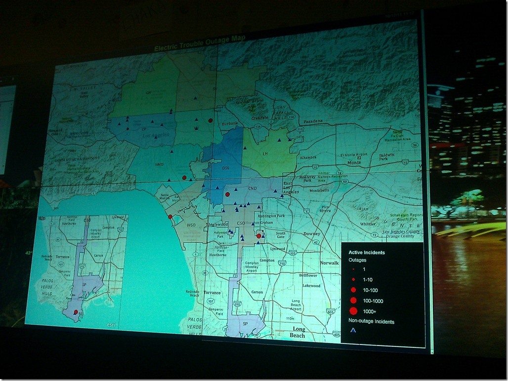
Recently, the major electric utility that I work for installed a wall full of 50”displays in their power outage response control center, and they asked me to start generating content for it. The content would be real-time summary data of the power outages across the utility’s electric distribution network, and the centerpiece was to be a map showing the location of all the current power outages affecting their customers.  This was an exciting challenge for me, since I’ve never created applications to be run on large screens with no human interface devices – keyboards, mice, etc. I was particularly excited about figuring out how to implement the map, since I typically develop mapping applications that are meant to be experienced inside of a web browser.

IMG_20111017_112021

Continue reading “How to Build a 5 Ft Tall Web Map, and Why You’d Want to”

Running The ArcGIS JavaScript API in a SquareSpace Site

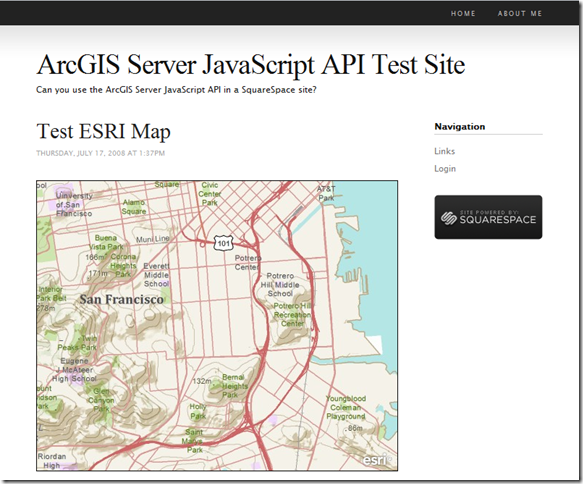
Just in case you are curious, SquareSpace does allow you to run ArcGIS Server JavaScript API code on their pages.  Here’s a screen shot of a I map made by copying and pasting code from the simple map sample into a SquareSpace page.

image

The only trick was to move the script tags out of the <head> section and into the <body>, since I don’t think that you are able to modify the <head>.  Here’s the complete code listing:

   1:  <div dojotype="dijit.layout.BorderContainer" design="headline" gutters="false" style="width: 100%; height: 100%; margin: 0;">
   2:        <div id="map" dojotype="dijit.layout.ContentPane" region="center" style="border:1px solid #000;padding:0;">
   3:       </div>
   4:      </div>
   5:      <script type="text/javascript">var djConfig = {parseOnLoad: true};</script>
   6:      <script type="text/javascript" src="http://serverapi.arcgisonline.com/jsapi/arcgis/?v=2.2"></script>
   7:      <script type="text/javascript">
   8:        dojo.require("dijit.layout.BorderContainer");
   9:        dojo.require("dijit.layout.ContentPane");
  10:        dojo.require("esri.map");
  11:   
  12:        
  13:        var map;
  14:        
  15:        function init() {
  16:          var initExtent = new esri.geometry.Extent({"xmin":-13632648,"ymin":4542594,"xmax":-13621699,"ymax":4546875,"spatialReference":{"wkid":102100}});
  17:          map = new esri.Map("map",{extent:initExtent});
  18:          //Add the topographic layer to the map.
  19:          var basemap = new esri.layers.ArcGISTiledMapServiceLayer("http://server.arcgisonline.com/ArcGIS/rest/services/World_Topo_Map/MapServer");
  20:          map.addLayer(basemap);
  21:          
  22:          //resize the map when the browser resizes 
  23:          dojo.connect(map, 'onLoad', function(theMap) { 
  24:            dojo.connect(dijit.byId('map'), 'resize', function() {  //resize the map if the div is resized
  25:              clearTimeout(resizeTimer);
  26:              console.log('resize');
  27:              resizeTimer = setTimeout( function() {
  28:                map.resize();
  29:                map.reposition();
  30:              }, 500);
  31:            });
  32:          });
  33:        }
  34:   
  35:        dojo.addOnLoad(init);
  36:      </script>

City of Pasadena Interactive Map Enhancements

The enhancements that I’ve been making to the interactive map on The City of Pasadena’s web site went live yesterday!

About the Project

The Google Maps based interactive map was originally developed (by another consulting firm) to help residents identify what neighborhood and city council districts they lived in.  A user entered an address, and the page would display a marker on the map with an info window listing the location’s city and neighborhood council districts.  Below the map the page would show a street view panorama of the location.  The user also had the option of viewing the city council district boundaries on the the map as KML overlays.

The City wanted to enhance the page by also displaying nearby features (such as libraries, transit stations, etc.) on both the map and the list.

Screen shot of The City of Pasadena Interactive Map

Continue reading “City of Pasadena Interactive Map Enhancements”

VEMap.Find Returns Italian Location from US Addresses (Los Angeles)?

This one took me a couple of minutes to figure out, so I thought I’d pass it along. Recently I launched an update to an application (in beta) that used the VEMap.Find method to geocode addresses in Los Angeles, CA, but for some reason the results for a few of the addresses would show up somewhere in Italy. Eventually I noticed that this was only happening for avenues (as opposed to streets or boulevards). I realized that our street database used the abbreviation “AV” instead of “AVE” and deduced that there must be an Italian province (Avellino?) that used that abbreviation and the parsing engine behind VEMap.Find must pick that out before the zip code.

My solution was to replace the word “AV” with “AVE” in the address string before passing it to the VEMap.Find function with the following:

address.replace(/\bAV\b/,"AVE")

So far, so good. I wonder how may more calls to replace I’ll end up daisy chaining on to that before I’m through with this one…

script.aculo.us Slide Show

My client, Terra Nova Pools, wanted to add a new page to their site that would display a looping slide show of before and after pictures of their clients’ pools. I decided to implement this page using this solution that relies on the script.aculo.us javascript library to fade a series of div tags in and out sequentially. The solution worked well with the exception of one small glitch – the screen seemed to jump between slides in FireFox (see comments on page above). I solved this by setting the position attribute for all slide divs to absolute with the following line of css:

div.slide { position: absolute; }

You can see the results at: http://www.terranovapools.com/clients/before-and-after/

I chose this solution because I knew I could rely on the script.aculo.us library to support a wide array of browsers as well as allow me to use web standards to ensure that the page would degrade nicely for users on mobile devices or older browsers. I had previously used Dynamic Drive’s ultimate fade in javascript slide show for the site’s home page, but that did not work at all in Safari and required defensive coding to be able to degrade nicely.